Every year, somewhere over warm tropical water, a scattering of thunderstorms begins to organize. Most of them fall apart within a day or two. A few do not. Those few draw energy up from the sea, begin to spin, and grow into the most powerful storms our atmosphere is capable of producing. Understanding what they are, how they form, and what they actually do to the places they hit is the difference between being caught off guard and being ready.
What Exactly Is a Hurricane?
A hurricane is a rotating storm system that feeds on the heat stored in tropical ocean water. It is not simply a very large thunderstorm; it is a heat engine, converting the warmth of the sea into wind through a cycle of rising moist air, condensation, and falling pressure at the center.
The dividing line is wind speed. Once maximum sustained winds reach 74 miles per hour (119 kilometers per hour), a tropical storm officially becomes a hurricane. Below that, at 39 miles per hour (63 kilometers per hour), it is a tropical storm. Below that, a tropical depression.
The same storm goes by different names depending on where in the world it forms. In the Atlantic and the Northeast Pacific it is a hurricane. In the Northwest Pacific it is a typhoon. In the South Pacific and Indian Ocean it is simply a cyclone. The physics are identical; only the vocabulary changes.
How a Hurricane Is Born
Hurricanes are surprisingly picky. Several conditions have to line up at once, which is why the tropics produce hundreds of disturbances a year and only a fraction ever become named storms.
Warm water, and plenty of it. The sea surface needs to be at least 80 degrees Fahrenheit (about 26.5 degrees Celsius), and that warmth has to extend down roughly 150 feet. A thin warm layer over cold water will not do; the storm churns up the ocean beneath it and quickly starves itself.
Moist air through the middle of the atmosphere. Dry air punching into a developing storm is one of the most common reasons it collapses. Saharan dust plumes drifting west across the Atlantic routinely smother would-be hurricanes for exactly this reason.
Low wind shear. If winds at high altitude are blowing much faster or in a different direction than winds at the surface, the storm gets tilted and torn apart before it can organize. Hurricanes need a calm vertical column to build in.
Distance from the equator. The spin comes from the Coriolis effect, a consequence of the Earth's rotation. That effect is essentially zero at the equator, which is why hurricanes almost never form within about five degrees of it.
When those conditions hold, a cluster of thunderstorms tightens into a tropical depression with a defined circulation. If it strengthens further it earns a name and becomes a tropical storm. And if the ocean keeps feeding it, the name that was a footnote last week becomes the name everyone is watching.
Anatomy of a Monster
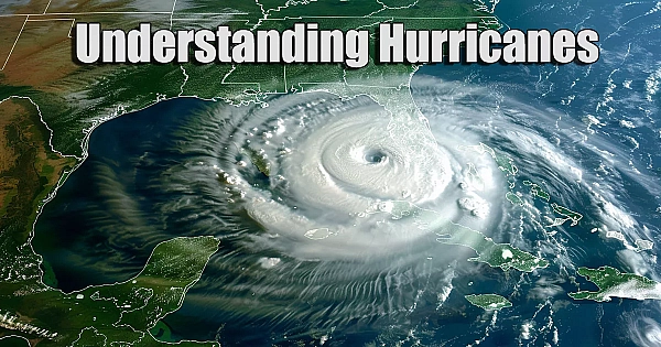
A mature hurricane has a structure so consistent that you can pick one out on satellite in a second.
At the center is the eye, a column of sinking air, often twenty to forty miles across, where the winds drop and the sky can open up to blue. It is genuinely calm, and it is genuinely a trap; people have walked outside during the eye and been caught when the far side of the storm arrived.
Wrapped around the eye is the eyewall, a ring of towering thunderstorms holding the storm's strongest winds and heaviest rain. Almost all of the catastrophic wind damage a hurricane inflicts comes from the eyewall passing over.
Spiraling outward are the rainbands, long curved arms of storms that can stretch hundreds of miles from the center. They are why a city well outside the forecast cone can still spend a day under flooding rain and tropical storm gusts.
Eyewall Replacement Cycles
Intense hurricanes sometimes grow a second eyewall outside the first. The outer ring gradually strangles the inner one, which collapses. During this process the storm's peak winds usually drop, which sounds like good news; it often is not. The rebuilt eyewall is wider, which means the field of damaging winds and the storm surge it pushes both get larger. A storm that weakens on paper during an eyewall replacement can arrive at the coast capable of doing more harm, not less.
The Saffir-Simpson Scale
Hurricanes are sorted into five categories based on sustained wind speed alone.
| Category | Sustained Winds | What to Expect |
|---|---|---|
| 1 | 74 to 95 mph | Damage to roofs, siding, and gutters. Large branches down, shallow-rooted trees toppled. Power outages lasting days. |
| 2 | 96 to 110 mph | Major roof and siding damage. Many trees snapped or uprooted, roads blocked. Near-total power loss lasting days to weeks. |
| 3 | 111 to 129 mph | Well-built homes lose roof decking and gable ends. Water and electricity unavailable for days to weeks. |
| 4 | 130 to 156 mph | Severe damage including loss of most of the roof structure and exterior walls. Areas left uninhabitable for weeks or months. |
| 5 | 157 mph and higher | A high percentage of framed homes destroyed. Most of the area isolated and uninhabitable for weeks or months. |
Category 3 and above is what meteorologists call a major hurricane.
The scale's most important limitation is what it leaves out. It says nothing about storm surge, nothing about rainfall, and nothing about the physical size of the storm. A sprawling Category 1 that stalls over a river basin can kill far more people than a compact Category 4 that comes ashore in a sparsely populated stretch of coast and moves on. Treating the category number as the whole forecast is one of the more dangerous habits a coastal resident can pick up.
Rapid Intensification
When a storm's winds increase by at least 35 miles per hour within 24 hours, forecasters call it rapid intensification. It happens when a hurricane finds unusually deep warm water under a near-perfect atmosphere, and it is the single hardest thing about hurricanes to predict.
The practical consequence is a timing problem. A storm can be a modest tropical storm when you go to bed and a major hurricane when you wake up, which compresses the window for evacuation from days into hours. This is why forecasters push people to prepare based on the forecast cone rather than the current category, and why a storm two days out being "only" a Category 1 is not a reason to relax.
The Many Faces of Hurricane Damage
Wind is what people picture, but it is rarely what kills them.
Storm surge is the ocean itself being pushed inland by the storm's winds, and historically it has been the deadliest hazard hurricanes produce. It can raise water levels by more than fifteen feet in a matter of hours, and because it arrives as moving water rather than a still flood, it takes structures apart. Surge depends heavily on the shape of the coastline and the slope of the seafloor, which is why two towns hit by the same storm can see wildly different water levels.
Inland flooding from rainfall has become an increasingly large share of hurricane deaths. Storms that slow down or stall can drop rain measured in feet, and that water has to go somewhere. Mountain terrain makes it worse, funneling runoff into narrow valleys and turning creeks into something unrecognizable. Some of the worst hurricane disasters on record have happened hundreds of miles from where the storm made landfall, in places that had never thought of themselves as hurricane country.
Tornadoes spin up in the outer rainbands, usually to the right of the storm's track. They tend to be weaker and shorter-lived than the tornadoes of the Great Plains, but they form fast, often with minimal warning, and they arrive in the middle of everything else that is already going wrong.
Wind does its damage through duration as much as speed. A structure that could survive a brief 100 mph gust may fail after several hours of sustained battering, and every piece of debris that comes loose becomes a projectile that damages the next thing downwind.
When Hurricane Season Runs
The Atlantic hurricane season officially runs from June 1 through November 30. The Eastern Pacific starts a bit earlier, on May 15. Storms occasionally form outside those windows, but the dates capture the overwhelming majority.
Activity is not spread evenly across those six months. The season builds slowly through June and July, ramps up sharply in August, and peaks around the second week of September, when ocean temperatures have had all summer to climb and wind shear across the Atlantic is typically at its lowest. Roughly the middle third of the season accounts for most of the damage.
How Hurricanes Get Their Names
Naming storms is not a marketing exercise; it is a safety measure. When three systems are active at once, "the hurricane" is a dangerously ambiguous phrase in a radio bulletin. Names eliminate the confusion.
The practice evolved in fits and starts. Military forecasters in the Pacific began informally naming storms during World War II. American forecasters then spent several years using a phonetic alphabet, which is why the historical record contains storms called Baker, Dog, and Easy. In 1953 the Atlantic switched to a list of female names, and in 1979 male names were added to the rotation.
Today the system is overseen by the World Meteorological Organization's Hurricane Committee. Six alphabetical lists of twenty-one names each are rotated, one per season, which means any given list comes back around every six years. Five letters are skipped entirely, Q, U, X, Y, and Z, because there simply are not enough common names beginning with them.
If a season is busy enough to exhaust its list, the overflow used to be handled with the Greek alphabet. That practice was abandoned after the 2020 season, partly because Greek letters proved confusing in public communication and partly because they created an awkward problem: a letter cannot be retired the way a name can. A supplemental list of ordinary names is now used instead.
Retired Names: The Storms We Never Repeat
When a storm is destructive or deadly enough, its name is struck from the rotation permanently and replaced with a new one starting with the same letter. Any member country can request a retirement, and the committee decides at its meeting the following spring.
The tradition began in 1955, after Carol, Edna, and Hazel tore through the northeastern United States the previous year. At first the retirement was meant to last only ten years, and a couple of names were briefly returned to service before the policy was changed in 1969 to make removals permanent. As of 2026, one hundred Atlantic names have been retired.
A few of those retirements tell you most of what you need to know about how hurricanes actually cause harm:
- Mitch (1998) is the deadliest name ever retired, killing more than ten thousand people in Central America; not through wind, but through days of rain and the landslides that followed.
- Katrina (2005) and Harvey (2017) are tied as the costliest, at roughly $125 billion each. Both did the bulk of their damage with water.
- Allison (2001) never became a hurricane at all. It was a tropical storm that parked over southeast Texas and flooded it, and it became the first storm of merely tropical storm strength to have its name retired.
- The 2005 season alone produced five retirements, a record that still stands.
More names beginning with the letter I have been retired than any other, a quirk of timing: the ninth storm of the season tends to arrive right at the September peak.
Not every bad year produces a retirement. Some seasons pass without a single name being removed, and the committee occasionally declines requests. The list is a record of consequence, not simply of strength.
Watches and Warnings: Know the Difference
These two words get used interchangeably in conversation, and they mean very different things.
A hurricane watch means hurricane conditions are possible in your area within 48 hours. This is when you finish your preparations, because the window for calm, unhurried work is closing.
A hurricane warning means hurricane conditions are expected within 36 hours. Preparations should already be complete. If an evacuation order is coming, this is roughly when it arrives.
Note that both are issued ahead of the storm's arrival, not when it gets there. The lead time is the whole point.
Preparing Before the Season Starts
The most useful hurricane preparation happens in May, not the week a storm has a name.
Build an emergency kit that does not require a trip to a picked-over store: one gallon of water per person per day for at least three days, non-perishable food, a manual can opener, prescription medications, a first aid kit, flashlights, batteries, and a battery or hand-crank radio. Cash matters more than people expect, because card readers do not work without power.
Make an evacuation plan in advance. Know your evacuation zone, know the route, and know where you are going. Pick an out-of-state contact everyone in the family can check in with, since long-distance lines often work when local ones are jammed. Make a plan for pets specifically; not every shelter accepts them, and finding that out during an evacuation is a bad time to learn it.
Handle your documents and insurance early. Photograph or scan insurance policies, identification, deeds, and medical records, and store copies somewhere they will survive the loss of your house. And understand this one clearly: standard homeowners insurance does not cover flood damage. Flood coverage is separate, and policies typically carry a thirty-day waiting period before they take effect, which means buying one with a storm in the forecast accomplishes nothing.
Securing Your Home
Boarding up windows is the visible part, but it is not the most important one.
Start with the roof, which is where catastrophic failures usually begin. Once wind gets under the roof deck and lifts it, the walls lose their bracing and the structure can unzip. Hurricane straps and clips tying the roof to the walls are among the most cost-effective upgrades available in a hurricane-prone area.
Reinforce the garage door. It is typically the largest and weakest opening on a house, and when it fails the wind pressurizes the interior and pushes outward on the roof from below.
Clear the yard. Patio furniture, grills, planters, and trash bins all become projectiles. Trim dead limbs well before the season rather than during it.
Check the drainage. Clogged gutters and blocked storm drains turn survivable rainfall into interior water damage.
Myths That Could Get You Hurt
Taping windows helps. It does not. Tape does nothing to stop a window from breaking and turns the failure into fewer, larger, more dangerous shards. Shutters or plywood work; tape is a waste of a morning.
Open windows to equalize pressure. This one has been debunked for decades and refuses to die. A house is not airtight, the pressure differential is not what destroys buildings, and open windows simply let wind and rain in.
The eye means it's over. The calm lasts anywhere from a few minutes to an hour, and the winds that follow arrive from the opposite direction, hitting structures that have already been weakened from the other side. Stay put until officials say the storm has passed.
I'm inland, so I'm fine. Freshwater flooding regularly kills people hundreds of miles from the coast, and hurricane-spawned tornadoes do not care about your distance from the beach.
I rode out the last one. Surviving a Category 2 tells you nothing about a Category 4. Wind damage does not scale in a straight line; the destructive force rises far faster than the wind speed does.
After the Storm
A surprising share of hurricane fatalities happen after the weather has cleared.
Generators produce carbon monoxide, which is colorless, odorless, and lethal. Run them outdoors and well away from windows and doors. Never in a garage, even with the door open.
Floodwater hides downed power lines, sharp debris, displaced wildlife, and sewage. Six inches of moving water can knock an adult off their feet, and two feet can move a vehicle. Do not walk or drive through it.
Downed lines should be treated as live regardless of appearance, and so should anything touching them, including fences and standing water.
Document damage with photographs before cleanup begins, and contact your insurer early; claim queues after a major storm get long fast.
Respect, Not Fear
Hurricanes are the most powerful storms the planet produces, and no amount of preparation makes one harmless. But the gap between the people who come through a major hurricane in reasonable shape and the people who do not is rarely luck. It is usually the plan made in May, the insurance bought before the forecast, the evacuation started early rather than late, and the willingness to take a forecast seriously before it becomes obvious.
Learn how these storms work, know your zone, and be ready before you need to be. The ocean will keep making them regardless.